Project
Radon Atlas of Canada
Client
Radon Environmental
Roles
Research, Copywriting,
Art Direction, Graphic Design
Radon Atlas of Canada
Client
Radon Environmental
Roles
Research, Copywriting,
Art Direction, Graphic Design
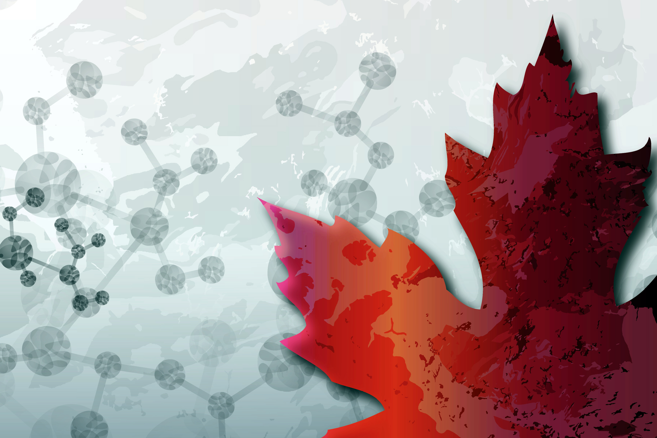 An invisible carcinogen in Canadian homes. Decades of geoscience data that couldn't translate itself to public urgency. Radon Environmental—a company preventing exposure to the second leading cause of lung cancer worldwide—needed something that didn't exist yet: a visual learning resource that could speak simultaneously to researchers, industry, property developers, and homeowners.


The Threshold
The gap wasn't just between science and public. It was between disciplines. Geoscientists understood bedrock. Health physicists understood dosage. Policy people understood building codes. But no one had a shared visual language for understanding geology's role in the radon story.
Thirty-five percent of countries have radon data mapped. Those maps increase awareness, guide building codes, prioritize where detectors go. Canada needed one. But how do you design for trust when the entire country is at some level of risk? How do you communicate "everywhere is dangerous, but differently" without paralyzing people?
The Work
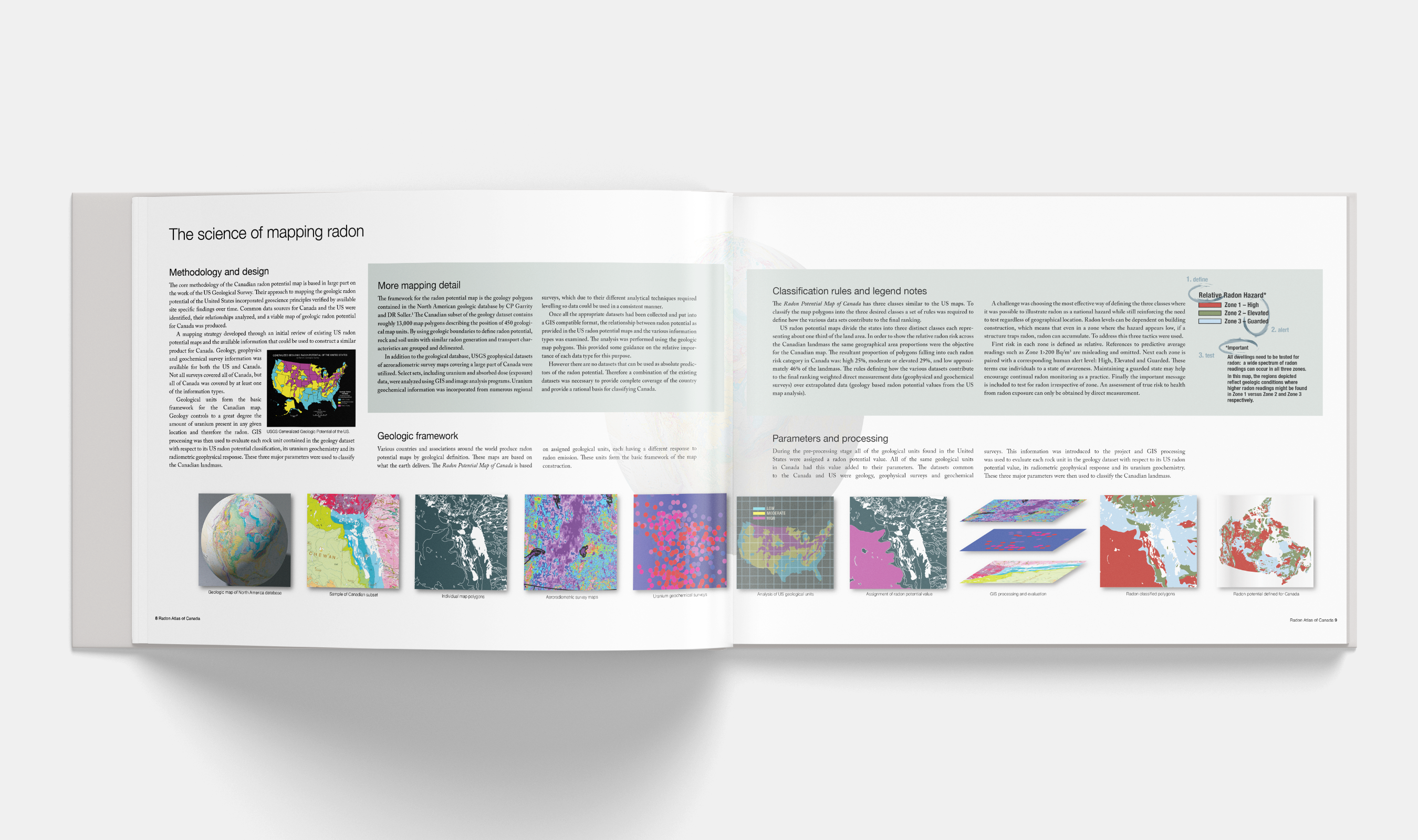
Embedded with geoscientists, GIS experts, entrepreneurs. Research phase moved between NRC mapping resources and government radon risk maps from other countries—looking for what makes a map legible to both experts and the public simultaneously.
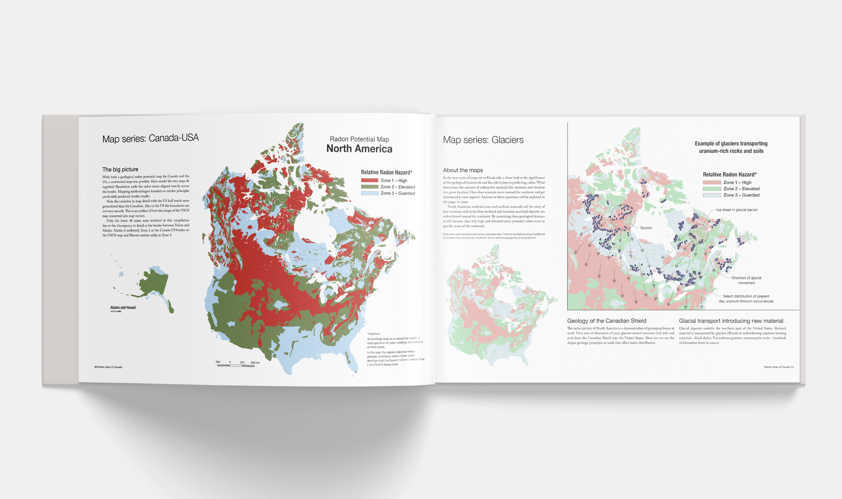
The design challenge landed on colour. Every zone had risk. The usual green-yellow-red didn't work—green implies safety, and nowhere was safe. Studied the USGS approach. Settled on three zones defined by color and human alert levels: red/high, green/elevated, blue/guarded. The colour strategy had to be accessible, had to match the level of urgency without inciting panic, had to let people locate themselves geographically and emotionally.
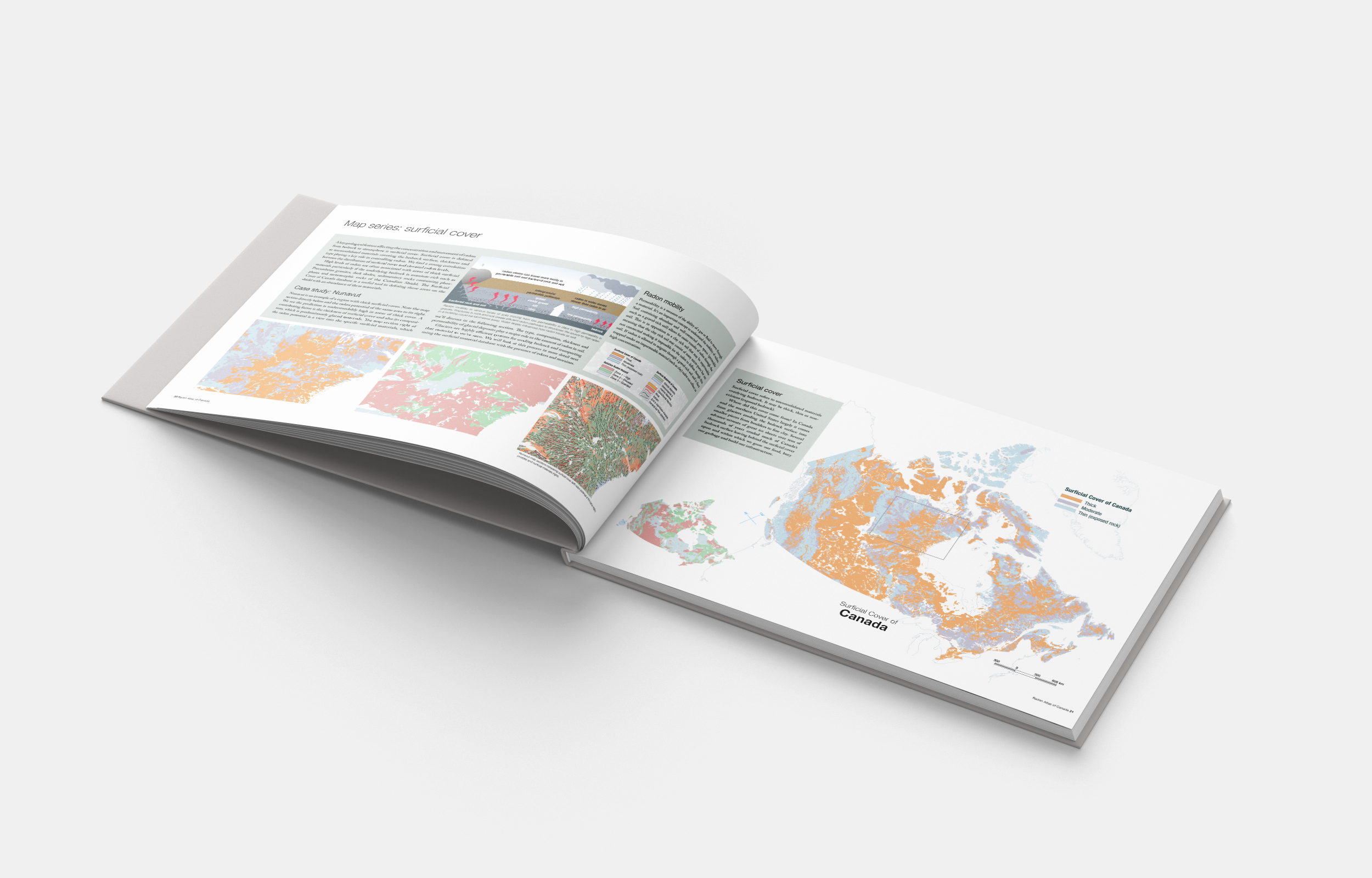
Developed the Radon Potential Map of Canada first—the base layer. Then built an overlay series with a tinted palette investigating relationships: human use and activity, regional population studies with First Nations, projected growth areas. Each overlay asking: where are people, where will they be, where does the ground beneath them hold the most risk?
The final form: a large-format book, digital and print. Not a government document but designed to feel like one—borrowing the visual authority of National Research Council publications to build trust. Plain language throughout. Full map series, introduction to health physics, mapping methodology, case studies showing how to read your own risk.
Worked across disciplines without flattening them. The geoscientists' precision held. The health communicators' clarity held. The design didn't simplify—it structured. Made the relationships visible.
The gap wasn't just between science and public. It was between disciplines. Geoscientists understood bedrock. Health physicists understood dosage. Policy people understood building codes. But no one had a shared visual language for understanding geology's role in the radon story.
Thirty-five percent of countries have radon data mapped. Those maps increase awareness, guide building codes, prioritize where detectors go. Canada needed one. But how do you design for trust when the entire country is at some level of risk? How do you communicate "everywhere is dangerous, but differently" without paralyzing people?
The Work
Embedded with geoscientists, GIS experts, entrepreneurs. Research phase moved between NRC mapping resources and government radon risk maps from other countries—looking for what makes a map legible to both experts and the public simultaneously.
The design challenge landed on colour. Every zone had risk. The usual green-yellow-red didn't work—green implies safety, and nowhere was safe. Studied the USGS approach. Settled on three zones defined by color and human alert levels: red/high, green/elevated, blue/guarded. The colour strategy had to be accessible, had to match the level of urgency without inciting panic, had to let people locate themselves geographically and emotionally.
Developed the Radon Potential Map of Canada first—the base layer. Then built an overlay series with a tinted palette investigating relationships: human use and activity, regional population studies with First Nations, projected growth areas. Each overlay asking: where are people, where will they be, where does the ground beneath them hold the most risk?
The final form: a large-format book, digital and print. Not a government document but designed to feel like one—borrowing the visual authority of National Research Council publications to build trust. Plain language throughout. Full map series, introduction to health physics, mapping methodology, case studies showing how to read your own risk.
Worked across disciplines without flattening them. The geoscientists' precision held. The health communicators' clarity held. The design didn't simplify—it structured. Made the relationships visible.
What Made It Possible
A client (Radon Environmental) who understood that communication was prevention. A team willing to work in the overlap: producer/editor Alan Whitehead, creative director/geoscience lead Dan Innes, geoscience consultants Frederick Breaks and Tom Morris, GIS lead Ward Kilby.
The recognition that this wasn't a branding project or a data visualization project but both—and neither. It was a translation project. Making geology legible as health risk. Making national-scale patterns meaningful at the scale of "should I test my home?"
Time to research how other countries had approached this. Access to the full geoscience data. Trust to develop a colour strategy that broke from convention because convention wasn't working.
First published 2011. Now in its third edition. Widely cited by Lung Associations, BC Centre for Disease Control, University of Calgary. Provincial and territorial maps now available for planners and developers. Published in the Canadian Journal of Public Health.
The outcome that matters: a shared visual intelligence across disciplines. Researchers, policy makers, property developers, homeowners—all looking at the same map, all able to act from it.
Credits
Research, Copywriting, Art Direction, Graphic Design: Alana McFarlane
Producer, Editor: Alan Whitehead
Creative Director, Geoscience Lead: Dan Innes
Geoscience Consultants: Frederick Breaks, Tom Morris
GIS Lead: Ward Kilby
Client: Radon Environmental
Publication
Hystad P, Brauer M, Demers PA, Johnson KC, Setton E, Cervantes-Larios A, Poplawski K, McFarlane A, Whitehead A, Nicol AM (2012) Geographic variation in radon and associated lung cancer risk in Canada. Canadian Journal of Public Health:105(1):e4-10. doi.org/10.17269/cjph.105.4002
